

How We Craft the Ultimate 3D Wooden Map
Every map tells a story - your story.
At the core of our map-making process is a passion for turning cherished memories and meaningful places into beautifully crafted works of art.
From the first spark of inspiration to the finishing touches, we blend creativity, precision, and personalisation to ensure every map is as unique as the journey it represents.
Crafted with care. Designed with professionalism.

STEP 1
Confirming the Location For Your 3D Map
The journey to creating a map starts with choosing the perfect location - it shapes the area, scale, and overall design.
With our collection of pre-designed maps, I use my expertise to craft each one with care and precision.
Looking for something unique? Just fill out our Custom Map Request form and share what you'd like included and why it matters to you.
From there, I’ll personally reach out to chat about your vision, ensuring I have all the details to bring the first draft of your map to life.
Let’s create something truly special together!
STEP 2
Creating the Design of Your Map
I bring maps to life by combining data from multiple sources to create designs that are both striking and accurate, blending topographic and bathymetric details seamlessly.
Once the raw data is collected, I transform and refine it, setting the stage for stunning map designs and precise laser cutting.

Finalising the Details
STEP 3
Once your map’s first draft is ready, I’ll carefully review the design to ensure it aligns perfectly with our design principles and stands out alongside our other creations.
For custom maps, I’ll personally connect with you to share the draft and discuss your vision. Together, we’ll make sure every detail captures the essence of your special time or place.
Once you’re thrilled with the final design, it’s off to manufacturing to bring your map to life!
STEP 4
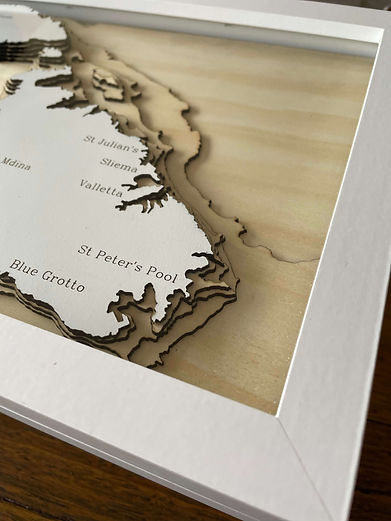
Laser Cutting and Framing Of Your 3D Map
Once the design is finalised, I bring it to life by laser-cutting each layer from 2mm Basswood plywood. The land is painted a crisp white, while place names and labels are carefully engraved, creating a clean, elegant finish. The natural grain of the plywood makes every map unique, adding a touch of character to each piece.
The assembly process is where the magic happens.
Layer by layer, island by island, I meticulously assemble everything into place with precision and care. Once complete, the map is set into a high-quality hardwood frame, secured with premium Fletcher-Terry frame points, and sealed with Kikusui picture framing tape to keep it dust-free.
The result? A stunning map, ready to be admired for years to come.


STEP 5
Delivery of Your 3D Wooden Map
I take great care to pack your map using multiple layers of eco-friendly materials, ensuring it’s safe, secure, and planet-friendly.
Each map is snugly and securely wrapped and packaged, so it arrives at your doorstep in perfect condition, every time.
For every order, I rely on Australia Post to deliver your map with care and reliability.